Camalaniugan is a landlocked municipality in the coastal province of Cagayan.
Camalaniugan is geographically situated in the midst of 4 municipalities of northern part of Cagayan province. It is bounded on the north by the municipality of Aparri, south by municipality of Lal-lo, east by municipality of Buguey, and west by municipality of Allacapan. It lies in a meridian of 121 o 40’57” east longitude and 18o16’5” north latitude. It has a land area of approximately 10,028.6745457 hectares.
Camalaniugan has 28 barangays as shown in the following table.
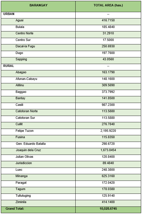
The municipality is politically subdivided into 28 barangays namely: Baggao, Bulala, Centro Norte, Centro Sur, Dacal-la Fugu, Dugo, and Sapping. These first seven (7) barangays comprised the urban core of the municipality. The other twenty-one (21) barangays are classified rural namely: Abagao, Afunan-Cabayu, Agusi, Alilinu, Bantay, Casili, Catotoran Norte, Catotoran Sur, Cullit, Felipe Tuzon, Fusina, Gen. Eduardo Batalla, Joaquin dela Cruz, Julian Olivas Sr., Jurisdiccion, Luec, Minanga, Paragat, Tagum, Tullutuging, and Ziminila. The above table shows that barangays Joaquin dela Cruz, and Casili has the biggest area of 1,151.2429 and 955.0364 hectares respectively. Barangay Centro Norte, Centro Sur and Sapping have the least land area of 6.1842, 4.3907 and 8.6446 hectares of the municipal land area respectively. The above table further reveals an area of approximately 507.9954 hectares as boundary disputes between the municipality and the municipalities of Lal-lo, Allacapan in the south portion and municipality of Buguey in the eastern part. The inclusion of said boundary dispute is purposely for planning exercise until such time the same will be settled among the affected municipalities.
Demographic profile of barangays


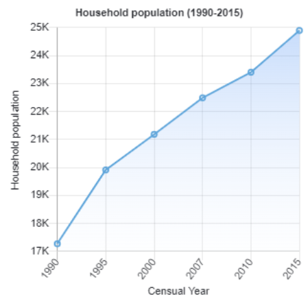
Households
The household population of Camalaniugan in the 2015 Census was 24,895 broken down into 5,482 households or an average of 4.54 members per household.


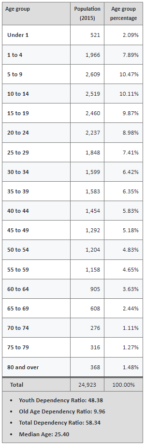
Population by age group
According to the 2015 Census, the age group with the highest population in Camalaniugan is 5 to 9, with 2,609 individuals. Conversely, the age group with the lowest population is 70 to 74, with 276 individuals.
Combining age groups together, those aged 14 and below, consisting of the young dependent population which include infants/babies, children and young adolescents/teenagers, make up an aggregate of 30.55% (7,615). Those aged 15 up to 64, roughly, the economically active population and actual or potential members of the work force, constitute a total of 63.15% (15,740). Finally, old dependent population consisting of the senior citizens, those aged 65 and over, total 6.29% (1,568) in all.
The computed Age Dependency Ratios mean that among the population of Camalaniugan, there are 48 youth dependents to every 100 of the working age population; there are 10 aged/senior citizens to every 100 of the working population; and overall, there are 58 dependents (young and old-age) to every 100 of the working population.
The median age of 25 indicates that half of the entire population of Camalaniugan are aged less than 25 and the other half are over the age of 25.


Economy
The annual regular revenue of Camalaniugan for the fiscal year of 2016 was ₱79,140,334.55.

The municipal center of Camalaniugan is situated at approximately 18° 17′ North, 121° 40′ East, in the island of Luzon. Elevation at these coordinates is estimated at 5.8 meters or 19.1 feet above mean sea level.
Distances
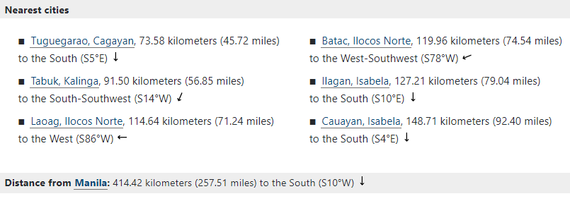
Based on the great-circle distance (the shortest distance between two points over the surface of the Earth), the cities closest to Camalaniugan are Tuguegarao, Cagayan, Tabuk, Kalinga, Laoag, Ilocos Norte, Batac, Ilocos Norte, Ilagan, Isabela, and Cauayan, Isabela. The nearest municipalities are Lal-lo, Cagayan, Aparri, Cagayan, Allacapan, Cagayan, Buguey, Cagayan, Ballesteros, Cagayan, and Gattaran, Cagayan. Its distance from the national capital is 414.42 kilometers (257.51 miles). The following list delineates such distance measurements.